
Geography Optional Answer Writing Day-8 Synopsis. The topic is Climatology and sub topic is Local winds, Monsoon, Jet streams etc. GeoVillae is the geography optional online learning platform.
Answer
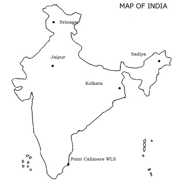
i) Srinagar
Srinagar is the largest city and the summer capital of the Indian state of Jammu and Kashmir. It lies in the Kashmir Valley on the banks of the Jhelum River, a tributary of the Indus, and Daland Anchar lakes. The city is known for its natural environment, gardens,waterfronts and houseboats. It is also known for traditional Kashmiri handicrafts and dried fruits.
The city is located on both the sides of the Jhelum River, which is called Vyath in Kashmir. The river passes through the city and meanders through the valley, moving onward and deepening in the Dal Lake. The city is known for its nine old bridges, connecting the tw o parts of the city.
ii) Jaipur
Jaipur is the capital and the largest city of the Indian state of Rajasthan in Northern India. It was founded on 18 November 1727 by Jai Singh II, the ruler of Amer, and after whom the city is named.
Jaipur has a hot semi-arid climate(Bsh) under Koppen’s climate classification. It receives over 63 cm of rainfall annually. But most rains occur in the monsoon months between June and September. Temperatures remain relatively high during summer from April to early July having average daily temperatures of around 27.6′ C. During the monsoon there are frequent, heavy rains and thunderstorms, but flooding is common.
iii) Sadiya
A city in Assam. Sadiya was the third capital of Chutia Kingdom established by the second Sutiya ruler Ratnadhwajpal in 1248 and remained as the capital till 1524. Extensive remains of buildings and fortifications built during the rule of the Chutias near about Sadiya still point to the importance of the region in the past.
According to mythology, Sadiya wasthe capital of the legendary king Bhirmuko which was sanskritised to Bhismak (whom the Chutiyas considers themselves as descendants of), but archeological evidence shows that this place was made a capital only during 7th-8th century.
iv) Point Calimere Wildlife Sanctuary
Point Calimere Wildlife and Bird Sanctuary (PCWBS) is a 21.47-square-kilometre (8.29 sq mi) protected area in TamilNadu, South India along the Palk Strait where it meets the Bay of Bengal at Point Calimere at the southeastern tip of Nagapattinam District. The sanctuary was created in 1967 for conservation of the near threatened blackbuck antelope, an endemic mammal species of India. It is famous for large congregations of waterbirds, especially greater flamingos.
v) Kolkata
Kolkata, also known as Calcutta is the capital of the Indian state of West Bengal. Located on the east bank of the Hooghly River approximately 75 kilometers (47 mi) west of the border with Bangladesh, it is the principal commercial, cultural, and educational centre of East India, while the Port of Kolkata is India’s oldest operating port and its sole major riverine port. The city is widely regarded as the “culturalcapital” of India and is also nicknamed the “City of Joy”.
Q.2) Explain the following terminologies in about 50 words each: (5 x 5 =25 marks)
Answer
i) Convective instability
Convective instability occurs when dry mid-level air advects over very warm and moist air in the lower troposphere. Convective instability is released when dynamic lifting from the surface to the mid-levels produces a moist adiabatic lapse rate of air lifted from the lower troposphere and a dry adiabatic lapse rate from air lifted in the middle troposphere. Dry air cools more quickly when lifted compared to moist saturated air.
In an unstable atmosphere, vertical air movements (such as in orographic lifting, where an air mass is displaced upwards as it is blown by wind up the rising slope of a mountain range) tend to become larger, resulting in turbulent airflow and convective activity.Instability can lead to significant turbulence, extensive vertical clouds, and severe weather such as thunderstorms.
ii) Wet adiabatic lapse rate
in an ascending air mass the reduced rate of temperature change caused by the addition of latent heat of condensation is called the wet/moist adiabatic lapse rate. Higher moisture content in a raising air lowers down the rate of temperature change, where as relatively drier air mass there is higher rate of temperature change.
It is to be noted that any parcel of raising air first cools at the dry adiabatic lapse rate from the surface to the condensation level. Beyond this level the rate of cooling is lowered due to the release of latent heat of condensation, and the same is known is known as wet adiabatic lapse rate.
iii) Trade wind belt
on the both sides of equatorial trough lie the trade wind belts extending roughly from 50 to 300of latitude. Here the surface flow is equatorward and flow in upper troposphere is poleward. Trade winds originate because of pressure difference in STHP and equatorial low pressure.
In the northern hemisphere the prevailing winds are N-E and are called northeast trades and in southern hemisphere they are S-E and are called as southeast trades. The zone of trade winds is also called as Hadley cell.
iv) Polar front cell
it is also called as Ferrel cell.This mid-latitude cell is thermally indirect. The cell is formed between 30deg. To 60 deg. N and S. the circulation pattern is just the reverse of tropical cell. The surface air flow is directed towards pole and upper air flow is towards equator.
In this cell the warm air from the tropics and the cold air from the poles collide to form the front and the front is called as polar front and there by it is called as polar front cell. Here major heat exchange takes place at the surface and aloft.
v) Katabatic wind
Katabatic wind is the generic term for downslope winds flowing from high elevations of mountains, plateaus, and hills down their slopes to the valleys or planes below. Katabatic winds exist in many parts of the World and there are many different names for katabatic winds depending where they are located and how they are formed.
Warm, dry katabatic winds occur on the lee side of a mountain range situated in the path of a depression. Examples for these descending, adiabatically warmed katabatic winds are the Foehn winds.
Cold and usually dry katabatic winds,like the Bora, result from the downslope gravity flow of cold, dense air.
Q.3) Explain the origin, progress and retreat of Indian monsoon and discuss its impact on Indian economy. (2018) (20 marks)
Approach
- Introduce with defining monsoon and its nature.
- Explain the origin of the monsoon (90 words).
- Progress of the monsoon i.e. Arabian and BoB branches. (90 words)
- Retreat of the monsoon another 70 words.
- Impact on Indian economy 90 words.
- Conclusion.
Answer
The vagaries and uncertainties of nature find their aerial manifestation in the Indian Monsoon- the bedrock of the Indian socio-economic framework.
The term monsoon refers to the wind system that exhibits the complete reversal in wind direction according to the change of season. These rhythmic shifts are the hallmark of Indian Monsoon.
Origin of the Indian Monsoon.
During the summer season, with the northward journey of the sun, establishes a low-pressure zone. The apparent movement of the sun places the ITCZ over the north India parallel to the mountain ranges.
Simultaneously the westerly jet stream withdraws itself from the northern region by mid-July. And winds from different directions are attracted towards low pressure zone i.e. ITCZ. The maritime tropical (mT) air of the southern hemisphere also gets attracted and after crossing the equator, takes the south-westerly course following the Ferrel law, hitting the Indian coasts as southwestern monsoon. This is called as the burst of the monsoon. This usually happens in the around 1st June.
At the upper air circulation, the easterly jet holds the commanding position which originated due to summer heating of the Tibetan highlands. These play a prominent role in steering the tropical depression into India, and thereby affecting the rainfall distribution over the subcontinent.
Following events aids the origin of the Indian Monsoon.
Tibetan high formed due to summer heating weakens the western subtropical jet streams and creates the easterly jet streams.
The Mascarenes High– the upper air easterlies originated over Tibetan plateau descend in the permanent high-pressure area formed over south Indian ocean (Mascarenes high). It is the main causative factor for the vigor of Indian Monsoon.
Progress of the Monsoon
The monsoon which hits the sub-continent divides and moves into two branches viz.
- Arabian sea branch
- Bay of Bengal branch
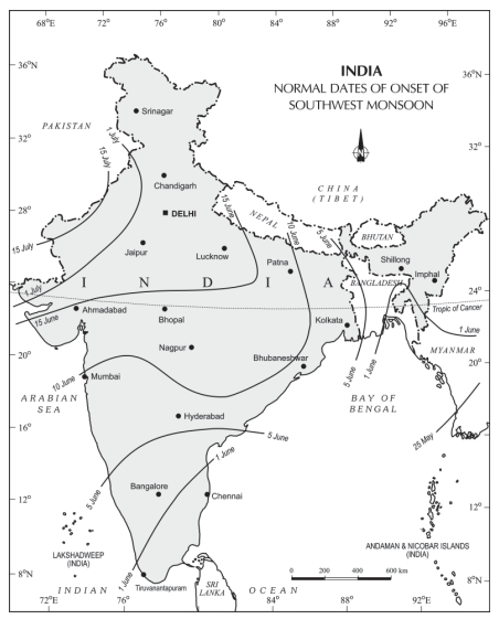
Arabian sea branch
- It is larger than the Bay of Bengal branch and the entire Arabian Sea branch advances towards India.
- The rainfall along the western coasts is orographic. At times when the winds blow parallel to Western Ghats, thereby there occurs no rain.
Bay of Bengal branch
This branch of winds blows parallel to the eastern coast of India and hence causes no rain. But after hitting the Arakanyoma hills deflects to the West Bengal and Bangladesh.
The one branch of this wind system brings rain to Meghalaya hill complex. And another west flowing wind brings widespread rain to the Indo-Gangetic rainfall.
However, there is steady decline in rainfall as we move from east to west, for example, Kolkata gets 119 cm,Patna 105cm, Allahabad 91cm, Delhi 51cm and Bikaner 21cm.
The months from June to September experience good number of depressions. Almost all of them are sucked inward through the deltas of great rivers like Ganges, Godavari, Krishna, Kaveri and Mahanadi.
Retreat of the Monsoon.
As the apparent movement of the sun starts to shift towards south by the end of September, winter season sets in. During this time high pressure created over central and western Asia gives rise to the blow of cold dry winds from central Asia to India.
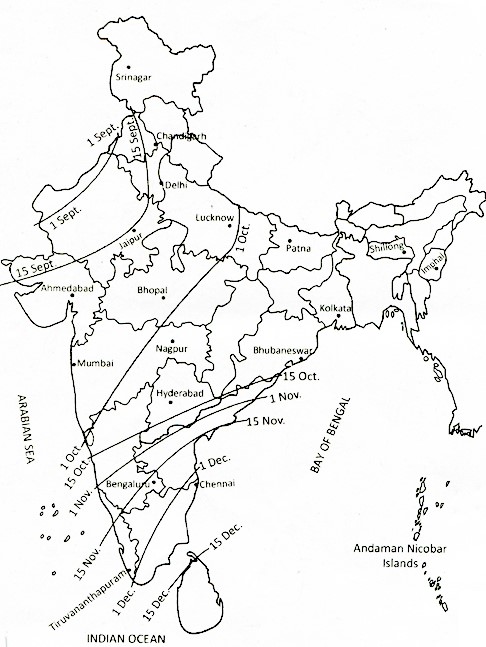
It withdraws from Rajasthan, Gujarat,Western Ganga plain and the Central Highlands by the end of the September. By the beginning of October, the low pressure covers northern parts of the Bay of Bengal and by early November, it moves over Karnataka and Tamil Nadu. By the middle of December, the centre of low pressure is completely removed from the Peninsula.
The retreat of the monsoon is steady phenomena unlike the burst of the monsoon. The weather during this season is characterized by high day temperatures, and pleasant nights.During this season severe cyclonic storms develop over Bay of Bengal.They give substantial rainfall on the eastern coast.
Impact of Monsoon on the Indian Economy
Impact on Indian Agriculture: The agriculture is the backbone of Indian economy because more than 50% of Indian population engaged in agriculture, which shares around 17.4% in the Indian gross domestic product. In case monsoon is favorable then we have a positive impact or if not favorable then then the prices of the goods increase and the services of other classes of people is diminished. Products of industry do not find a ready market and the supply of raw materials to industries also suffers.
Impact on GDP (Gross Domestic Product):If monsoon fails then it will reduce the percentage points from the overall GDP growth of India. This will also have an unfavorable effect on demand in the non-agricultural sector.
Impact on Balance of Trade: if the monsoon is favorable,we have a favorable balance of trade and if the monsoon is not favorable we have a negative balance of trade. The failure of the monsoon affect sun favorably the volumes and the balance of India’s foreign trade.
Impact on the food supply: If monsoon failed, it will hamper the agricultural production, which would stroke on the food prices.
Impact on the hydro-power sector and irrigation facilities: Most of the Indian power project installed on the Perennial Rivers. If monsoon fails, it would lower the water levels that have detrimental effects on the power generation as well as irrigation facilities.
Impact on rural economy: India’s rural life revolving around agriculture and allied activities in small villages, where most of the population lives (68%).
Hence there is a pressing need to adopt an integrated spatio-temporal approach to water resource management to make this gamble with the monsoons a less risky phenomena, paving the way for regional prosperity and sustainable development.
Q.4) With suitable examples, bring out the impact of local winds on the climate of an area. (2013) (15 marks)
Approach
- Define local winds in introduction.
- Take 4 loacl winds and explain how they impact on the local climate.
- write conclusion with the significance of the local winds.
Answer
Local winds are certain type of winds produced by topographical peculiarities or local temperature differences. Since these winds are generated by purely local factors and their zone of influence is quite limited, ad have been classified as local winds.
Local winds are classified as land and sea breezes, hot and cold winds.
Land and sea breezes like any other winds have a significant influence on the environment. When the sea breezes move far in land over some tropical islands or other localities, they bring great relief to the inhabitants of those areas who aptly call the local winds as doctor.Example Harmattan.
Foehn is a warm dry wind on the lees ide of mountain range Alps. This warm, dry dusty wind is common in Switzerland. With the arrival of these winds there is rapid rise in temperature. In winter and early spring these winds cause rapid melting of snow and help in spring farming.
The beginning of the Foehn is marked by sharp rise in temperature and sudden drop in the relative humidity of air.
Chinook another dry, warm wind like Foehn blows on the eastern side of Rocky mountain range. These winds are common in winter and early spring. With the onset of these winds the snow present in the ground suddenly melts away. There is an increase of 22 deg.Celsius in the area affected by chinook. These winds reduce the severity of winter and beneficial to ranchers as grasslands thrives.
Blizzard is a violent and extremely cold wind laden with dry snow picked from the ground. It represents severe weather conditions characterised by very low temperatures, strong winds, and a great amount of snow.
Thus, the local winds greatly modify the local climates of the region and are both beneficial and harmful to the economy of the regions.
Q.5) What is sustainable rural development? What is the need for improving the status of women and their role in rural development? (15 marks)
Reference
Kurukshetra September 2018 magazine.
Answer
It refers to improving the quality of life for the rural poor by developing capacities that promote community participation, health, education, food security, environmental protection and sustainable economic growth thereby enabling community members to leave the cycle of poverty & achieve their full potential.
The need for improving the status of women
- Rural women are the key agents for achieving the transformational economic, environmental and social changes required for sustainable development.
- Empowering them is crucial not only to the well being of individual families and rural communities but, also to the overall economic productivity as many are employed in the agriculture sector.
- A woman is the nucleus of a family particularly in rural India and it is a necessity to improve their status.
- Rural women have been ignored fraction of the society since Independence.
- Gender equality is rightly seen as crucial to sustainable development, with its own Sustainable Development Goal (Goal 5).
- Women and girls face unacceptable levels of discrimination and abuse, which is not only wrong, but also prevents them from playing a full part in society and decision-making.
- Women are key managers of natural resources and powerful agents of change.
Role of women in rural sustainable development
- Women play a key role in food production and form a large proportion of the agricultural work force globally (43 per cent of the agricultural labour force in India).
- Women are harbinger of social justice. Their presence in Panchayats enables to form gender sensitive initiatives.
- Women are good at resource use efficiency and conservation, they are empathetic to the animals and are passionate about nature.
- Women are sensitive about health issues and are key players in eradicating pollution and maintaining health and hygiene.
- Women play greater role in eradicating illiteracy and spreading education.
- Women are more vulnerable to environmental degradation and climate change but also have different perspectives, concerns and ideas for change.
Keeping these things in mind the policy formulation has to be done. And is imperative that for the progress of the nation half of its population has to be empowered.
Dear geovillage team, where is the download option of synopsis of day 7 as well as this one, nevertheless may God bless for this noble initiative, unfortunately due to tight schedule of working in m not able to write, but every day I go through these questions and Google the terms where necessary,
We deeply regret the inconvenience caused. Now it has been enabled. As we are in the process of enabling automatic pdf download for each of the post, we had stopped download option. But we are continuing this till we upgrade the software. Happy to serve you guys.