
Geography Answer Writing Day-10 Synopsis. This is not the model answer. Here we have been providing the framework and approach to the answers
Q.1) On the outline map of India, mark the location of all the following. Write the significance of these locations, whether physical/commercial/economic/ecological/ environmental/cultural, in not more than 30 words for each entry.: (2 x 5 =10 marks)
Answer
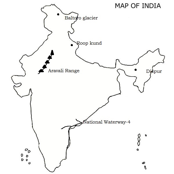
i) Dispur
Dispur, a locality of Guwahati, became the capital of Assam in 1973. This was after Shillong, the erstwhile capital, became the capital of the state of Meghalaya that was carved out of Assam.
Shilpagram is famous for cultural and handicraft heritage of Assam and other northeastern states. Ethnic jewellery, carpets, silk sarees, wooden and metal handicrafts are available here among others.
Basistha Ashram is six kilometers from Dispur. It is popular for Lord Shiva temple. The temple spread across 835 bighas of land. It stands on the bank of mountain streams which originates from the hills of Meghalaya which in turn becomes river Basistha and Bharalu that flows through the city.
Srimanta Sankaradeva Kalakshetra is a cultural institution located at Panjabari area of the region. The museum preserves the culture and tradition of Assam as well as the Northeast. It is named after the great cultural exponent and scholar of Assam Mahapurush Srimanta Sankardeva. Inside the museum could be found traditional jewellery, costumes, statues, articles, weapons, stone and inscriptions displaying the not only the culture of Assam but the whole northeast as well.
ii) Aravali range
The Aravalli Range is a range of mountains running approximately 692 km (430 mi) in a southwest direction, starting in North India from Delhi and passing through southern Haryana, through to Western India across the states of Rajasthan and ending in Gujarat.
The Aravalli Range, an eroded stub of ancient mountains, is the oldest range of fold mountains in India.
The Northern Aravalli range in Delhi and Haryana has humid subtropical climate and hot semi-arid climate continental climate with very hot summers and relatively cool winters.
iii) Roop kund
Roopkund (locally known as Mystery Lake, Skeletons Lake) is a high-altitude glacial lake in the Uttarakhand state of India. It lies in the lap of Trishul massif and is famous for the hundreds of human skeletons found at the edge of the lake.
The area is uninhabited, in the Himalayas at an altitude of 5,029 meters (16,499 feet). Surrounded by rock-strewn glaciers and snow-clad mountains, the lake is a popular trekking destination.
iv) Inland water way-4
National Waterway 4 (NW-4) is 1,095 kilometers (680 mi) long waterway in India. It has been declared as an Indian National Waterway and is currently under development. It connects the Indian states of Telangana, Andhra Pradesh, Tamil Nadu, and the union territory of Puducherry.
The NW-4 runs along the Coromandal Coast through Kakinada, Eluru, Commanur, Buckingham Canals and also through part of Krishna and Godavari rivers in South India. It was declared a National Waterway on 24 November 2008 under the Provisions of National Waterways Bill, 2006.
V) Baltoro glacier
The Baltoro Glacier at 63 km (39 mi) in length, is one of the longest glaciers outside the polar regions. It is located in the Gilgit-Baltistan of PoK. It runs through part of the Karakoram mountain range.
The glacier gives rise to the Shigar River, which is a tributary of the Indus River. Several large tributary glaciers feed the main Baltoro Glacier, including the Godwin Austen Glacier, flowing south from K2; the Abruzzi and the various Gasherbrum Glaciers, flowing from the Gasherbrum group of peaks; the Vigne Glacier, flowing from Chogolisa, and the Yermandendu Glacier, flowing from Masherbrum. The confluence of the main Baltoro Glacier with the Godwin Austen Glacier is known as Concordia; this location and K2 base camp are popular trekking destinations.
Q.2) Explain the following terminologies in about 50 words each: (5 x 5 =25 marks)
i) Tropical humid climate (A)
- This type of climate found in low latitudes on both sides of equator typically 20 to 40 degree on both hemispheres.
- There is no winter season in this climatic group.
- Temperature is uniformly high throught the year with adequate annual rainfall.
- There is o occurrence of frost in any part of the year.
- In marine location the average temperature of the coldest month is above 18 degree Celsius.
- This is sub divided into two groups viz. Tropical wet climate (Ar) and Tropical wet-and-dry climate (Aw).
ii) Tropical wet and dry climate
- Distinct wet and dry seasons of relatively equal duration.
- Most of the region’s annual rainfall is experienced during the wet season and very little precipitation falls during the dry season.
- A lengthy dry season and a relatively short wet season.
- During winter these climatic groups are dominated by anticyclones.
- To the contrary, in summer these are controlled by dry trade winds and equatorial westerlies.
- The trees found here are deciduous forest and tree-studded grasslands, and it is often referred to as Savanna Climate.
iii) Temperate marine climate
- This is the sub group within the broader microthermal climatic type. It is characterised by mild winters.
- Average temperature for all the months is 0 degree Celsius or above.
- It is found on the western windward side of the continents in temperature zone.
- This is the humid climate with adequate precipitation at all seasons.
iv) Boreal climate
- Boreal climate is found in the higher middle latitudes. It is super-continental in temperature features.
- The summers are short and cool. The winters are long and very cold with a very short frost-free season.
- One to three months during the year have average temperatures of 10-degree C or above.
- Average temperatures for the rest of the year are below 10 degree Celsius.
- These regions are characterized by the lowest annual means of temperature for any part of the earth.
- Even though boreal climates are classified as humid, annual precipitation is generally meagre. Precipitation occurs throughout the year.
- However, most of the precipitation occurs during the warmer months when the amount of water vapor present in the air is highest.
- Coniferous forest is the predominant natural vegetation.
- Because of the severity of climate, population in this type of climate is sparse.
- This group of climates is also called the subarctic type of climate.
v) Dry climates
- The boundaries of the dry type of climatic group are fixed by precipitation values.
- The characteristic feature of a dry climate is that the loss of moisture through evapotranspiration is far in excess of the annual receipt of water gain from precipitation.
- Because of clear and calm weather and the dry atmosphere, the dry climates are severe for their latitudes.
- Extreme seasonal temperatures cause large annual ranges of temperature.
- Daily ranges of temperature are still more pronounced.
- Annual average precipitation in these climates is always meagre and highly variable.
- Thus, the meagerness and undependability are the two distinguishing features of precipitation in this great climatic group.
- Other salient features of the dry climates are low relative humidity, high potential evaporation, abundant sunshine, and small cloudiness.
On the basis of annual average precipitation, the dry climates have been classified into two climatic types:
(1) BW — the arid, or desert type, and
(2) BS — the semi-arid, or steppe type.
Q.3) Discuss the basis of Koppen’s climatic classification. Bring out the salient characteristics of ‘Cs’ type of climate. (2015) (20 marks)
Approach
- Introduce the significance of climatic classification.
- The first part of the question asks the basis of the Koppen’s classification not the overall classification. So just mention the basis of classification for 1st order, 2nd order and third order.
- Then write in detail about the features of Cs type of climate.
Answer
Climatic classification is very important for geographers and scientists, just by identifying the climatic types, we are able to predict various associated visible aspects of the environment and it is also possible that just by looking at the vegetation, animals, soils or landforms geographers can predict the climate of the region.
The climatic classification of Wladimir Koppen is still the most used and well-known system of climatic classification. It is both empirical and quantitative classification of the climate.
Koppen proposed his first classification in 1900 and revised it in 1918, 1931 and 1936. And the basis of his climatic classification and further revisions are as follows.
In his 1900 classification Koppen used the vegetation map of the world prepared by de Candole as the basis.
He used certain critical values of temperature for warmest and coldest months and precipitation of wettest and driest months.
Based on these parameters he divided the world into 5 principle climatic regions viz. Megatherms, Xerophytes, Mesotherms, Microtherms and Hekistotherms.
In his 1918 revision of climatic classification he paid attention to
- the monthly ad annual averages of temperatures and precipitation and
- their seasonal distribution.
- Vegetational correspondence.
In this classification he divided the 5 principle climatic zones A to E based on the above parameters.
It is a multilevel classification wherein he introduced 2nd and 3rd order classification. In 2nd order he described precipitation and in 3rd order temperatures.
In his further 1931 and 1936 classification he addresses the distinct type of climates within the broader climatic regions such as Ganges type temperature regime etc.
Features of Cs type of climate
- The Cs type climate in Koppen climatic classification stands for the principle climatic region C- Humid mesothermal climates or warm temperate rainy climates.
- The average monthly temperature of coldest month is below 18 degree Celsius but above -3 degree Celsius.
- The average temperature of warmest month is greater than 10 degree Celsius.
- Both winter and summer seasons are found.
- In this type of climatic region, the summer is dry, and winter receives the rain.
- The regions are located to the tropical margins of the midlatitude along the western sides of the continents.
The climatic classification of Koppen is the pioneer attempt and having lot of criticisms still it stands widely used classification due its simplicity, empiricism and precisely defined regions.
Q.4) What is Potential Evapotranspiration? Explain how it is used in assessing the water balance in an area. (2015) (15 marks)
Approach
- Define PE in introduction. And explain it.
- Explain its use in assessing in water balance in an area.
Answer
Potential evapotranspiration or PE is a measure of the ability of the atmosphere to remove water from the surface through the processes of evaporation and transpiration assuming no control on water supply. Actual evapotranspiration or AE is the quantity of water that is actually removed from a surface due to the processes of evaporation and transpiration.
The following factors are extremely important in estimating potential evapotranspiration:
Potential evapotranspiration requires energy for the evaporation process. The major source of this energy is from the Sun. The amount of energy received from the Sun accounts for 80% of the variation in potential evapotranspiration.
Wind is the second most important factor influencing potential evapotranspiration. Wind enables water molecules to be removed from the ground surface by a process known as eddy diffusion.
The rate of evapotranspiration is associated to the gradient of vapor pressure between the ground surface and the layer of atmosphere receiving the evaporated water.
How PE is used to assess the water balance in an area?
Around the world humans are involved in the production of a variety of plant crops. Many of these crops grow in environments that are naturally short of water. As a result, irrigation is used to supplement the crop’s water needs.
Managers of these crops can determine how much supplemental water is needed to achieve maximum productivity by estimating potential and actual evapotranspiration. Estimates of these values are then used in the following equation:
crop water need = potential evapotranspiration – actual evapotranspiration
- PE is also used in calculating the ground water recharge by using the actual surface water availability and PE.
- River regimes of small and medium basins can be analyzed using PE along with their discharges to the other rivers and seas.
- PE is being used in soil moisture estimation and crop management.
- PE is used in assessing the lake water availability and future loss owing to the less precipitation in dry regions.
- The historical PE and present PE are used to gauge climate change impact in an area.
- The integrated water shed management uses PE to assess the water balance and to further decide the crops to be grown, animals to be reared etc.
Q.5) Examine the performance of National Action Plan on Climate Change so far. (15 marks)
Approach
- Introduction – why we need NAPCC.
- Then define NAPCC and explain its objectives.
- Write its achievements so far.
- Its short comings and failures.
- Conclude with suggestion for policy improvement.
Answer
According to the Global Climate Risk Index of 2018, India is the 12th most vulnerable country to climate change impacts. Every year, it witnesses an average of 3,570 deaths attributable to climate-related events, and the cost of climate change impact it will pay is projected to run into trillions of dollars in the near future.
The Action Plan was released on 30th June 2008. It effectively pulls together a number of the government’s existing national plans on water, renewable energy, energy efficiency agriculture and others – bundled with additional ones – into a set of eight missions.
Emphasizing the overriding priority of maintaining high economic growth rates to raise living standards, the plan “identifies measures that promote development objectives while also yielding co-benefits for addressing climate change effectively.”
Following are the list of NAPCC
- National Solar Mission
- National Mission for Enhanced Energy Efficiency
- National Mission on Sustainable Habitat
- National Water Mission
- National Mission for Sustaining the Himalayan Ecosystem
- National Mission for a Green India
- National Mission for Sustainable Agriculture
- National Mission on Strategic Knowledge on Climate Change
- A Ninth Mission – Government to Prepare a National Bio-energy Mission
The guiding principles of the plan are:
- Inclusive and sustainable development strategy to protect the poor
- Qualitative change in the method through which the national growth objectives will be achieved i.e. by enhancing ecological sustainability leading to further mitigation
- Cost effective strategies for end use demand side management
- Deployment of appropriate technologies for extensive and accelerated adaptation, and mitigation of greenhouse gases
- Innovative market, regulatory and voluntary mechanisms to promote Sustainable Development
- Implementation through linkages with civil society, local governments and public-private partnerships
- International cooperation, transfer of technology and funding
Achievements
National water mission created 702 hydrological observation stations against a target of 800.
NMSHE and NMSKCC aim to generate new information; build scientific and technical capacity; and produce new channels of collaboration between scientists, policy-makers and law-makers to ensure that climate action is based on sound knowledge and science.
The two missions have been instrumental in expanding body of Indian scientific literature on climate change. Since 2011, a total of 850 publications have come out of these missions.
The number of annual publications from projects funded by the DST’s climate change programmes has increased nearly 15 times between 2011 and 2018.
Currently, there are about 150 projects or programmes that have been launched under the two missions, up from close to 50 in 2016.
NATIONAL SOLAR MISSION (NSM) The mission has a target of 20 GW installed solar capacity by 2022. In 2015, the Government of India revised its target for JNNSM to 100,000 MW (or 100 GW) by 2022, which includes 40 GW through rooftop solar and 60 GW through large- and medium-scale grid connected solar power projects.
As of July 31, 2018, the country has total installed capacity of 21.8 GW and the target for 2022 has already been met. The budget for the mission has also gone up, from Rs 350 crore in 2010 to Rs 9,187 crore in 2017-18.
NMEEE- Perform, Achieve and Trade (PAT) is the most important initiative under the mission. Rolling out an energy efficient economy is a key feature of India’s strategy to deal with climate change and PAT seeks to address this issue.
PAT is being implemented in four cycles. In Cycle-I (2012–15), eight energy intensive sectors were included: thermal power plants, iron and steel, cement, fertilizer, aluminum, textile, pulp and paper, and chloralkali.
In Cycle-I, energy savings have been 30 per cent more, at 8.67 million tonnes of oil equivalent (mtoe) than the target set in the first phase.
Shortcomings or failures
There are several other challenges that the missions face.
One, the monitoring system is either absent or ineffective.
Two, the budgetary support by the government is very limited. Considering the scant domestic and international channels for finance, the government needs to mobilise funds from different sources.
Three, states have to frame their own action plans, or State Action Plans on Climate Change (SAPCC), in line with NAPCC. But SAPCCs framed by almost all the states are vague.
The NWM is not taken off yet. Though goals have been set, the strategy to achieve them has not been prepared. States are supposed to formulate State Specific Action Plans (SSAPs) to mitigate and adapt to the impacts of climate change.
Initially, in 2007, the government proposed an allocation of Rs 20,000 crore under the 11th Five Year Plan. This was slashed to Rs 15,000 crore in the 12th Plan (2012-2017). During 2012-2015, the Union budgets altogether allocated a paltry Rs 350 crore to the mission. But only Rs 2.16 crore was spent till 2015.
In the last 10 years, just 1,237 water bodies have been rejuvenated as against a target of 10,000 for which nearly Rs 265 crore was sanctioned. Similarly, just 24 additional forecasting stations and 36 additional water quality monitoring stations have been set up till 2017, compared to targets of 100 and 113 respectively.
NMSHE and NMSKCC – But despite the jump in research publications and the creation of networks, research largely remains disparate and unconnected. Almost none of the research has translated into any policy action.
In fact, the apparent overlap in the objectives of the two missions is not by design. These have remained woefully neglected and nearly nothing has moved on the ground.
National Solar Mission- The weakest part of campaign for going solar is the generation from rooftop sources. To achieve its target of 40 GW installed capacity by 2022, India should have an installed capacity of 10,000 MW by 2017-18. However, only 1,222 MW of rooftop capacity has been installed till July 31, 2018.
NATIONAL MISSION ON SUSTAINABLE HABITAT (NMSH) – But even eight years after its launch, NMSH has no specific funds. In fact, it did not seek any such support from ministries concerned.
The Union government lists its four flagship programme—Atal Mission on Rejuvenation and Urban Transformation (AMRUT), Swachh Bharat Mission (Urban), Smart Cities Mission and Urban Transport Programme—as means to implement the mission.
It is safe to say that NMSH has been reduced to an umbrella term for other urban development programmes. Many of its objectives have been incorporated into other missions (for example, effective waste management is covered under Swachh Bharat Mission (Urban) and development of public transport under AMRUT), but its main purpose to tackle cities as a climate agenda stands defunct.
NATIONAL MISSION FOR SUSTAINABLE AGRICULTURE (NMSA) – Agriculture, which is source of livelihood for more than 50 per cent of India’s population, will be the worst impacted by climate change.
India’s challenge here is two-fold: it must adapt to the impacts of climate change and also reduce emissions from agriculture.
The mission, however, has lagged behind its target in implementation of planned schemes. There has been a continuous gap between expenditure and allocation of budget for increasing adaptive capacity. Between 2003-04 and 2014-15, only 13 per cent of total budget allocated under climate change programmes was spent by the agriculture ministries of the states.
GREEN INDIA MISSION (GIM) – However, the budgetary allocation for the mission has been shrinking over the years.
The allocations for the years 2015-16, 2016-17 and 2017-18 were Rs 72 crore, Rs 42.01 crore and Rs 47.80 crore respectively.
In terms of targets, the data available for the year 2015-16 and 2016-17 shows that the mission has missed its targets by a long shot.
So, considering the above trends in NAPCC it has gained mixed results. So, in order to gear up our effort towards sustainable development the center and state in co-ordination has to develop the policies and should devise the financial mobilization schemes for the programs.
As far as the implementation part concerned, it must rope all the stakeholders from individuals to state, labors to industrialists etc.