
GAWP 2019 Day-12 Synopsis. This is not the model answer. It is the synopsis and approach to the answer which helps you to get maximum marks in the exams. Geography optional learning made easy and simple with this initiative. The objective of this exam is to enable aspirants to score more than 300 marks in the CSE Mains exam.
Click here to download the GAWP Day-12 Synopsis
Q.1) On the outline map of India, mark the location of all the following. Write the significance of these locations, whether physical/commercial/economic/ecological/ environmental/cultural, in not more than 30 words for each entry.: (2 x 5 =10 marks)
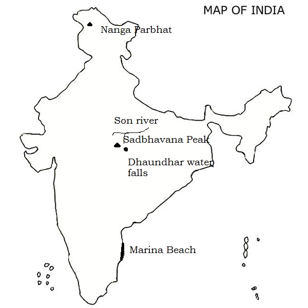
Nanga Parbat locally known as Diamer, is the ninth highest mountain in the world at 8,126 metres above sea level. It lies just south of the Indus River in the Diamer District of Gilgit–Baltistan in PoK. Not far to the north is the western end of the Karakoram range.
Nanga Parbat along with Namcha Barwa on the Tibetan Plateau mark the west and east ends of the Himalayas.
ii) Sadbhawna Shikhar
The highest point of the Vindhyas is the Sad-bhawna Shikhar (“Goodwill Peak”), which lies 752 m above the sea level. Also known as the Kalumar peak or Kalumbe peak, it lies near Singrampur in the Damoh district, in the area known as Bhanrer or Panna hills.
The “Vindhyan Supergroup” is one of the largest and thickest sedimentary successions in the world.
iii) Dhuandhar falls
The Dhuandhar Falls are located on Narmada River in Bhedaghat and are 30 meters high. The Narmada River, making its way through the world-famous Marble Rocks, narrows down and then plunges in a waterfall known as Dhuandhaar. The plunge, which creates a bouncing mass of mist, is so powerful that its roar is heard from a far distance.
iv) Marina beach
Marina Beach is a natural urban beach in Chennai, Tamil Nadu, India, along the Bay of Bengal. The beach runs from near Fort St. George in the north to Foreshore Estate in the south, a distance of 6.0 km (3.7 mi), making it the longest natural urban beach in the country.
Marina Beach lies on the stretch of coast where olive ridley sea turtles, a species classified as Schedule 1 of the Indian Wildlife Protection Act of 1972 (critically endangered), nest during mating season, chiefly between late October and April peaking from mid-January to mid-February.
v) Son river
Son River of central India is the second largest of the Ganges’ southern tributaries after Yamuna River. The Kabra khurd is a beautiful place on the banks of the son river, primarily due to its picnic spots.
The first dam on the Son was built in 1873–74 at Dehri. The Indrapuri Barrage was constructed, 8 kilometers upstream, and commissioned in 1968. The Bansagar Dam in Madhya Pradesh was commissioned in 2008.
Q.2) Explain the following terminologies in about 50 words each: (5 x 5 =25 marks)
i) Continental slope
The zone of steep slope extending from the continental slope to the deep-sea plains is called as continental slope. And accounts for about 8.5% of oceanic surface area. Its seaward limit is bounded by 2000 fathom isobath also marks the end of continental block. The depth of water over continental varies from 200m to 2000m.
The steep slope does not allow any material to deposit. The most significant features of the continental slopes is the submarine canyons and trenches.
ii) Mid-Atlantic ridge
Mid-Atlantic ridge represents the zone of divergent plate margin is the most striking feature of the Atlantic Ocean. It extends from Iceland in the north to Bouvet island in the south. It is known as Dolphin rise in the north and Challenger Rise in the south of equator. It is known as Wyville Thompson Ridge between Iceland and Scotland.
At the equator the ridge sends off two branches. The major peak o the ridge are Pico islands of Azores. Besides these it has well marked fracture zones e.g. Gibbs fracture zone, Atlantis fracture zone, etc.
iii) Abyssal hills
An abyssal hill is a small hill that rises from the floor of an abyssal plain. They are the most abundant geomorphic structures on the planet Earth, covering more than 30% of the ocean floors. Abyssal hills have relatively sharply defined edges and climb to heights of no more than a few hundred meters. They can be from a few hundred meters to kilometers in width. A region of the abyssal plain that is covered in such hill structures is termed an “abyssal-hills province”. However, abyssal hills can also appear in small groups or in isolation.
iv) Submarine canyon
Long narrow and very deep valleys or trenches located on the continental shelves and slopes with slopes with vertical walls resembling the continental canyons are called submarine canyons because of their location under oceanic waters.
The longitudinal course of submarine canyons is sinuous. The gradient of sub marine canyons is steeper than the continental canyons. The floors of canyons have coarser material than the adjacent continental shelves. The deposits include sand, silt, clay and pebbles.
v) Bathymetry
Bathymetry is the study of underwater depth of lake or ocean floors. In other words, bathymetry is the underwater equivalent to hypsometry or topography. Bathymetric (or hydrographic) charts are typically produced to support safety of surface or sub-surface navigation, and usually show seafloor relief or terrain as contour lines (called depth contours or isobaths) and selected depths (soundings), and typically also provide surface navigational information.
Bathymetric maps (a more general term where navigational safety is not a concern) may also use a Digital Terrain Model and artificial illumination techniques to illustrate the depths being portrayed. The global bathymetry is sometimes combined with topography data to yield a Global Relief Model. Paleo-bathymetry is the study of past underwater depths.
Q.3) Describe the configuration of the Pacific Ocean floor (2017) (20 marks)
Answer
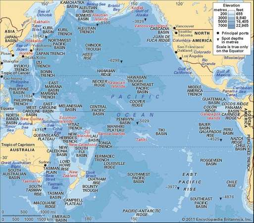
The Pacific Ocean, the largest ocean of the world having one-third area of the globe, the overall shape of the ocean is triangular if its extent in both the hemispheres is considered separately. Average depth of the ocean in 4,572m. Both the Coasts (east and west) of the Pacific are paralleled by the chains of folded mountains and therefore the descent from the coast to the abyssal plains is very steep.
More or less uniform broad and extensive ocean floor is characterized by several swells, rises, sea mounts and depressions (trenches and deeps). The Ocean has the largest number Of islands (more than 2,000). It may be pointed out that the western coast is studded with islands, island arcs and festoons while the eastern coast has only a few islands.
Islands
The islands of the Pacific are grouped in 3 categories e.g.
(1) the continental islands (Ateutian Islands. islands off British Columbia of Canada, and Chilean island),
(2) island arcs and festoons (Kuriles, Japanese Archipilago, Philippines and Indonesian islands), and
(3) scattered smaller islands which are further subdivided into two major sub-categories e.g. (i) islands based on racial grouping such as (a) Malanesia (Solomons, New Hebrides and Fizi), (b) Micronesia (Marshal’s, Carolines, Gilbert and Ellice), and (c) Polynesia (Society, Cook, and Tuamotu) and
(ii) islands formed of volcanic materials and coral reefs (Hawaii island-volcanic island, Fizi, Faunafuti, Ellice etc. coral islands).
Continental Shelf
There is significant difference in the extent and characteristics of continental shelves on the eastern and western coasts of the Pacific. The shelves are quite broad and extensive along the eastern coasts of Australia and Asia where the width varies from 160 km to 1600 km and the depth ranges between 1000 m and 2000m.
Several islands are seated on these broad continental shelves (viz. Kuriles, Japanese islands, Philippines, Indonesia. New Zealand etc.)
These continental shelves also carry numerous marginal seas like Bering Sea, Okhotsk Sea, Japan Sea, Yellow Sea, China Sea, Java Sea, Coral Sea, Tasmania Sea, Arafura Sea etc.
The continental shelve are less extensive along the western coasts of Americas because of nearness of cordilleran chains of folded mountains to the coastal lands. The average width is 80 km.
East Pacific Rise
The Pacific Ocean does not have central or mid-oceanic ridge like the Atlantic and the Indian Oceans, albeit there are a few scattered ridges having local importance. The East Pacific Rise or Ridge known as Albatross Plateau is 1600 km wide and it extends from north of New Zealand to the Californian coast.
It sends off two branches between 23 0 S-35 0 S. The eastern branch merges with Chilean coast while the other branch moves southward in the name of Eastern Island Rise. A minor ridge known as Galapagos Ridge runs parallel to the East Pacific Ridge in the east between the Eastern Island Fracture Zone and Galapagos islands from where it moves in two branches viz. (i) Carnegic Ridge and (ii) Cocos Ridge in north-east direction.
The New Zealand Ridge is about 200m to 2000 m below sea level and widens near Fiji island to form Fiji Plateau which is 2000 m below sea level.
The Hawaiian Rise extends from north-west to south-east direction between 35 degree N -17 degree N for a distance of 960 km. This is the most extensive ridge (2640 km wide) of the Pacific Ocean.
Ocean Basins
There are different basins of different shapes and sizes. These basins are separated by ridges and rises. The following are a few important basins of the Pacific Ocean.
(1) Philippine basin is located to the east of Philippines and extends from south of Japan to 50N latitude. Kyushu – Paian Ridge runs through the middle of the basins. Average depth ranges from 5000m to
(2) Fiji basin is located to the south of Fiji Island between 10-degree S and 32-degree S latitudes and the average depth is 4000m. The basin to the north of is known as North Fiji Basin whereas the South Fiji Basin between 20-degree S and 32 degree S is bordered by Norkolk Island Ridge in the west and Karmadec – Tonga Trenches in the east.
(3) East Australian basin is situated between the east coast of Australia and New Zealand Ridge with average depth of more than 5000m.
(4) South Australian Basin also known as Jeffreys Basin is located to the south-east of Australia having average depth of 5000m.
(5) Peru basin is located to the west of Peru coast between 5-degree S and 24 degree S latitudes and extends up to 110 W longitude. The average depth of the basin is 4000m.
(6) South-Western Pacific basin is an elongated basin stretching between 200S and 500S latitudes and 180-129-degree W longitudes. Karmadec Trench with the depth of 10.047 m is located to the west of this basin.
(7) Pacific Antarctic Basin is located to the south- west of Chilean coast between 40 degree S and 60 degree S latitudes and extends up to 130 degree W longitude.
Oceans Deeps
There are several trenches and deeps in the Pacific Ocean. These depressions are located either along the island arcs or mountain chains. It may be pointed out that the trenches are found mainly in the western Pacific Ocean. The following are the significant trenches Mariana, Tonga, Kurile, Philippine, Japan, Karmadec, Peru-Chile, Aleutian.
Q.4) Discuss Maritime Zones. (2016) (15 marks)
Answer
The maritime zones recognized under international law include internal waters, the territorial sea, the contiguous zone, the exclusive economic zone (EEZ), the continental shelf, the high seas and the Area. The breadth of the territorial sea, contiguous zone, and EEZ (and in some cases the continental shelf) is measured from the baseline determined in accordance with customary international law as reflected in the 1982 Law of the Sea Convention.
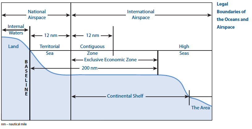
Baseline
Baseline is the low-water line along the coast as marked on large-scale charts officially recognized by the coastal State.
Internal Waters
Internal waters are the waters on the landward side of the baseline from which the breadth of the territorial sea is measured. Each coastal State has full sovereignty over its internal waters as if they were part of its land territory. The right of innocent passage does not apply in internal waters. Examples of internal waters include bays, rivers and even lakes that are connected to the sea, e.g., the Great Lakes.
Territorial Sea
Each coastal State may claim a territorial sea that extends seaward up to 12 nautical miles (nm) from its baselines. The coastal State exercises sovereignty over its territorial sea, the airspace above it, and the seabed and subsoil beneath it. Foreign flag ships enjoy the right of innocent passage while transiting the territorial sea subject to laws and regulations adopted by the coastal State that are in conformity with the Law of the Sea Convention and other rules of international law relating to such passage.
Contiguous Zone
Each coastal State may claim a contiguous zone adjacent to and beyond its territorial sea that extends seaward up to 24 nm from its baselines. In its contiguous zone, a coastal State may exercise the control necessary to prevent the infringement of its customs, fiscal, immigration or sanitary laws and regulations within its territory or territorial sea, and punish infringement of those laws and regulations committed within its territory or territorial sea. Additionally, in order to control trafficking in archaeological and historical objects found at sea, a coastal State may presume that their removal from the seabed of the contiguous zone without its consent is unlawful.
Exclusive Economic Zone
Each coastal State may claim an Exclusive Economic Zone (EEZ) beyond and adjacent to its territorial sea that extends seaward up to 200 nm from its baselines (or out to a maritime boundary with another coastal State).
Within its EEZ, a coastal State has:
(a) sovereign rights for the purpose of exploring, exploiting, conserving and managing natural resources, whether living or nonliving, of the seabed and subsoil and the superjacent waters and with regard to other activities for the economic exploitation and exploration of the zone, such as the production of energy from the water, currents and winds;
(b) jurisdiction as provided for in international law with regard to the establishment and use of artificial islands, installations, and structures, marine scientific research, and the protection and preservation of the marine environment, and
(c) other rights and duties provided for under international law.
Continental Shelf
Each coastal State has a continental shelf that is comprised of the seabed and subsoil of the submarine areas that extend beyond its territorial sea throughout the natural prolongation of its land territory to the outer edge of the continental margin, or to a distance of 200 nm from its baselines where the outer edge of the continental margin does not extend up to that distance (or out to a maritime boundary with another coastal State).
Wherever the outer edge of a coastal State’s continental margin extends beyond 200 nm from its baselines, it may establish the outer limit of its continental shelf in accordance with Article 76 of the UN Convention on the Law of the Sea. The portion of a coastal State’s continental shelf that lies beyond the 200 nm limit is often called the extended continental shelf.
A coastal State has sovereign rights and exclusive jurisdiction over its continental shelf for the purpose of exploring it and exploiting its natural resources. The natural resources of the continental shelf consist of the mineral and other non-living resources of the seabed and subsoil together with living organisms belonging to sedentary species, that is to say, organisms which, at the harvestable stage, either are immobile on or under the seabed or are unable to move except in constant physical contact with the seabed or subsoil.
High Seas
The high seas are comprised of all parts of the sea that are not included in the exclusive economic zone, the territorial sea or the internal waters of a State, or in the archipelagic waters of an archipelagic State.
Waters Forming International Straits
International straits are those areas of overlapping 12 nautical mile territorial seas that connect one area of the high seas or EEZ to another area of the high seas or EEZ and are used for international navigation. Part III of the Law of the Sea Convention (articles 34-45) describes the regime for transit passage through such straits as well as the rights and jurisdiction of the States bordering it. Transit passage is the right of a ship or aircraft to transit, pass or navigate through an international strait in a continuous and expeditious manner.
Comparative Sizes of the Various Maritime Zones
Areas of the Earth covered by the Oceans approx. 335.0 million km2
- High Seas 200.4 million km2
- Territorial Seas 22.4 million km2
- Contiguous Zones 6.6 million km2
- Exclusive Economic Zones 101.9 million km2
- Total areas under national jurisdiction excluding
extended continental shelves beyond 200nm 131.0 million km2
Q.5) The Fourth Industrial Revolution is about empowering people, not the rise of the machines. Elucidate. (15 marks)
answer
The change brought by the Fourth Industrial Revolution is inevitable, not optional. And the possible rewards are staggering: heightened standards of living; enhanced safety and security; and greatly increased human capacity.
How the Fourth Industrialization empowers the people?
Mindset shift
I believe people with grit, creativity and entrepreneurial spirit will embrace this future, rather than cling to the status quo.
People can be better at their jobs with the technology of today—and the technology that is yet to come—rather than fearing that their human skills will be devalued.
Human and machine
Software and technology have the potential to empower people to a far greater degree than in the past—unlocking the latent creativity, perception and imagination of human beings at every level of every organization.
The world will always need human brilliance, human ingenuity and human skills. And the artificial intelligence aids human in their endeavor.
Power of data, power of people
This shift will enable workers on the front line, on the road and in the field to make smarter decisions, solve tougher problems and do their jobs better. For example – the diagnosis of the Tesla car when it break-down is easier than that of the other cars due to inbuilt software which automatically diagnoses the issue.
New solutions
Software has forecast when, why and how the machine is likely to break down using predictive analytics.
A mechanic can then simply pick up an iPad and learn in a few minutes exactly what is about to break down, as well as the machine’s history and the conditions it’s been operating under.
Virtuous loop
That leaves the mechanics to do what they do best: fix it, using their experience, judgement and skill. And the mechanics decisions and actions become data that feeds back into the software, improving the analytics and predictions for the next problem.
So, technology didn’t replace mechanics; it empowered them to do their job.
In short, when the mechanic and the technology work together, the work gets done faster, with fewer errors and better results.
Multiply this across all industries: aviation, energy, transportation, smart cities, manufacturing, natural resources, and construction.
The productivity we unleash could be reminiscent of what the world saw at the advent of the first industrial revolution. But the impact of the Fourth Industrial Revolution will run much broader, and deeper, than the first.
We’ll have the knowledge, the talent and the tools to solve some of the world’s biggest problems: hunger, climate change, disease.
Machines will supply us with the insight and the perspective we need to reach those solutions. But they won’t supply the judgement or the ingenuity. People will.