
GAWP 2019 Day-13 Synopsis. This is not the model answer. It is the synopsis and approach to the answer which helps you to get maximum marks in the exams. Geography optional learning made easy and simple with this initiative. The objective of this exam is to enable aspirants to score more than 300 marks in the CSE Mains exam.
Click here to download the GAWP Day-13 Synopsis.
Q.1) On the outline map of India, mark the location of all the following. Write the significance of these locations, whether physical/commercial/economic/ecological/ environmental/cultural, in not more than 30 words for each entry.: (2 x 5 =10 marks)
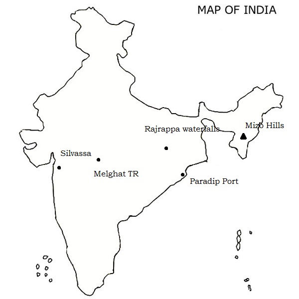
Silvassa is the capital of the Indian Union Territory of Dadra and Nagar Haveli. During Portuguese rule, Silvassa was also known as Vila de Paço d’Arcos. The city has a large number of factories and industries providing significant government revenue, which allows the city to maintain a low level of taxation. The city was chosen as one of the hundred Indian cities in Narendra Modi’s flagship Smart Cities Mission.
Rajrappa stands at the confluence of the Damodar and Bhairavi (locally called Bhera) rivers. Rajrappa Falls has tremendous geographical significance. The Damodar valley at Rajrappa is a typical example of polycyclic valley or topographic discordance which is characterized by two storey valley. The Damodar developed its broad and flat valley of senile stage before the onset of Tertiary upliftment. The river was rejuvenated due to upliftment of landmass during the Paleogene and Neogene Periods (66 million to 1.8 million years ago) by the side effects of the Himalayan orogeny and thus the Damodar excavated its new deep and narrow valley of youthful stage within its broad and flat valley of senile stage. The Bhera river coming from over the Ranchi plateau makes a waterfall while joining the Damodar and thus presents an example of a hanging valley. The Damodar gorge near Rajrappa is a typical example of incised meander.
Melghat was declared a tiger reserve and was among the first nine tiger reserves notified in 1973-74 under the Project Tiger. The Tapti River and the Gawilgadh ridge of the Satpura Range form the boundaries of the reserve. In 1985 Melghat Wildlife Sanctuary was created. The Tapi river flows through the northern end of the Melghat Tiger Reserve, through a forest which lies within the catchment area of the river system. Many different kinds of wildlife, both flora and fauna, are found here.
The Lushai Hills (or Mizo Hills) are a mountain range in Mizoram and Tripura, India. The range is part of the Patkai range system and its highest point is 2,157 m high Phawngpui, also known as ‘Blue Mountain’
The hills are for the most part covered with dense bamboo jungle and rank undergrowth; but in the eastern portion, owing probably to a smaller rainfall, open grass-covered slopes are found, with groves of oak and pine interspersed with rhododendrons. The Blue Mountain is the highest peak in Lushai hills.
Paradip Port is a natural, deep-water port on the East coast of India in Jagatsinghpur district of Odisha. It is situated at confluence of the Mahanadi river and the Bay of Bengal. It is situated 210 nautical miles south of Kolkata and 260 nautical miles north of Visakhapatnam.
Q.2) Explain the following terminologies in about 50 words each: (5 x 5 =25 marks)
- Thermocline
A thermocline (also known as the thermal layer or the metalimnion in lakes) is a thin but distinct layer in a large body of fluid (e.g. water, as in an ocean or lake; or air, e.g. an atmosphere) in which temperature changes more rapidly with depth than it does in the layers above or below. In the ocean, the thermocline divides the upper mixed layer from the calm deep water below.
Factors that affect the depth and thickness of a thermocline include seasonal weather variations, latitude, and local environmental conditions, such as tides and currents.
- Heat budget of oceans
Heat budget, in general, suggests that the total supply of energy is balanced by the loss of equal amount of energy. Mosby viewed that the average annual surplus of insolation between the equator (0°) and 10°N latitude was about 0.170 gm cal/ cm2/min, while it is about 0.040 gm cal/cm2/min. between 60°N to 70°N. This difference of surplus of insolation completely disappears if we take all the latitudinal regions into consideration.
- Pycnocline layer
A layer, zone, or gradient of changing density, esp. a thin layer of ocean water with a density that increases rapidly with depth.
The pycnocline, situated between the mixed layer and the deep layer, is where water density increases rapidly with depth because of changes in temperature and/or salinity. Recall that cold water is denser than warm water and salty water is denser than fresh water. Where a decline in temperature with depth is responsible for the increase in density with depth, the pycnocline is also a thermocline. On the other hand, if an increase in salinity is responsible for the increase in density with depth, the pycnocline is also a halocline.
- Halocline
Halocline, vertical zone in the oceanic water column in which salinity changes rapidly with depth, located below the well-mixed, uniformly saline surface water layer. Especially well-developed haloclines occur in the Atlantic Ocean, in which salinities may decrease by several parts per thousand from the base of the surface layer to depths of about one kilometre (3,300 feet). In higher latitudinal areas of the North Pacific in which solar heating of the surface waters is low and rainfall is abundant, salinities increase markedly with depth through the halocline layer. Pycnoclines, or layers through which water density increases rapidly with depth, accompany such haloclines inasmuch as density varies directly with total salt content.
- Photic zone
Photic zone, surface layer of the ocean that receives sunlight. The uppermost 80 m (260 feet) or more of the ocean, which is sufficiently illuminated to permit photosynthesis by phytoplankton and plants, is called the euphotic zone. Sunlight insufficient for photosynthesis illuminates the disphotic zone, which extends from the base of the euphotic zone to about 200 m. The thicknesses of the photic and euphotic zones vary with the intensity of sunlight as a function of season and latitude and with the degree of water turbidity. The bottommost, or aphotic, zone is the region of perpetual darkness that lies beneath the photic zone and includes most of the ocean waters.
Q.3) ‘’Temperature, salinity and density differences in ocean water are the prime causes of ocean water circulation.’’ Elaborate. (2011) (20 marks)
Approach
- Define oceanic water circulation in introduction.
- Draw the thermohaline circulation map.
- Explain the factors viz. temperature, salinity and density cause the ocean circulation.
- Draw the diagrams for upwelling and downwelling separately.
- Conclude with sustainable development.
Answer
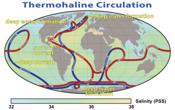
Figure 3.1 Thermohaline circulation
Ocean circulation is the large-scale movement of waters in the ocean basins. Winds drive surface circulation, and the cooling and sinking of waters in the polar regions drive deep circulation.
Winds drive ocean currents in the upper 100 meters of the ocean’s surface. However, ocean currents also flow thousands of meters below the surface. These deep-ocean currents are driven by differences in the water’s density, which is controlled by temperature (thermo) and salinity (haline). This process is known as thermohaline circulation.
How temperature, salinity and density cause oceanic water circulation?
Temperature Difference—The amount of insolation received at the earth ‘s surface and consequent temperature decreases from equator towards the poles. Due to high temperature in the equatorial region the water density decreases because of greater expansion of water particles whereas the density of sea water becomes comparatively greater in the polar areas.
Consequently, water moves due to expansion of volume from equatorial region (of higher temperature) to polar areas (colder areas) of relatively very low temperature.
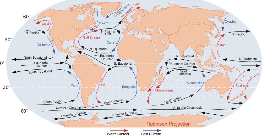
There is movement of ocean water below the water surface in the form of subsurface current from colder polar areas to warmer equatorial areas in order to balance the loss of water in the equatorial areas. Thus, the poleward surface currents and equatorward subsurface currents form a complete circulatory system of ocean water. The Gulf Stream and Kuroshio warm currents moving from equator towards north are examples of such currents.
Salinity Difference—Oceanic salinity affects the density of ocean water and density variation causes ocean currents. Salinity increases the density of ocean water. If two areas having equal temperature are characterized by varying salinity, the area of high salinity will have greater density than the area of low salinity.
The denser water sinks and moves as subsurface current whereas less saline water moves towards greater saline water as surface current. In other words, ocean currents on the water surface are generated from the areas of less salinity to the areas of greater salinity.
Such system of surface and sub-surface currents caused by salinity variation is originated in open and enclosed seas. For example, the current flowing from the Atlantic Ocean to the Mediterranean Sea via Gibraltar Strait is caused because of salinity difference. In fact, the salinity of the Mediterranean Sea is much higher than adjoining Atlantic Ocean. Consequently, water Sinks in the Mediterranean Sea. In order to compensate the loss of water Atlantic water flows as surface current into the Mediterranean Sea.
The sinking water in the Mediterranean Sea moves as subsurface current towards the Atlantic Ocean. Similarly, such system of surface and subsurface currents is generated between the Red Sea and the Arabian Sea via Babel Mandeb Strait. The salinity of the Baltic Sea is lowered due to the now of fresh water by the rivers, but the level of water is raised. With the result water moves northward as a surface current into the North Sea and subsurface current moves from the North Sea to the Baltic Sea.
Density Difference—ln fact, difference in the density of oceanic water is the main cause for the movement of oceanic water as ocean currents. Water density depends on a number of factors e.g. temperature, salinity, pressure etc. In other words, density the function of temperature, pressure and salinity.
As a rule, water moves from the areas of lower density to the areas of higher density. The density of water also decreases due to influx of freshwater resulting from melting of ice in the polar areas. High density is caused due to significantly very low insolation in the polar areas but at some places density is lowered due to influx of melt-water.

Fig 3.2 temperature, salinity and density effect on ocean water circulation
Consequently, cold water moves as cool current from polar areas towards the equator. East Greenland current is supposed to be caused by this factor. It may be pointed out that the factors of pressure, temperature, salinity and density should be considered together and not separately. It may be summarized that low-density water is lighter and hence expands and moves forward as surface current towards higher where there is sinking of water. The high-density water then moves as sub-surface current from greater density to lesser density below the water surface.
Natures exploitation by man has not left even oceans where the thermohaline circulation receives the threats from the global warming. It is the need of the hour to walk the talk on sustainable development so as to keep the ocean integrity intact to save the living beings on earth from extinction.
Q.4) Comment on marine heat budget and the oceanic circulation system (2009) (15 marks)
Approach
- Define heat budget in introduction.
- Mention heat input and output factors and processes.
- Write in brief about Oceanic water circulation.
- Conclude.
Answer
The oceanic heat budget consists of inputs and outputs. “Input” identifies a process through which the ocean gains heat, while “output” represents a heat loss to the ocean. A complete list of all inputs and outputs is as follows; + indicates input or heat gain, – signifies output or heat loss:
Primary inputs and outputs
- radiation from the sun (+)
- long-wave back radiation (-)
- direct heat transfer air/water (transfer of sensible heat) (-; + when from air to water)
- evaporative heat transfer (-; + when condensation; this situation occurs very rarely, mainly during sea fog conditions)
- advective heat transfer (currents, vertical convection, turbulence) (- or +); this effect cancels on the global scale or in closed basins
Secondary sources
- heat gain from chemical/biological processes (+)
- heat gain from the earth’s interior and hydrothermal activity (+)
- heat gain from current friction (+)
- heat gain from radioactivity (+)
The contributions from secondary sources are negligible for most applications.
Oceanic circulation system
Ocean circulation is the large-scale movement of waters in the ocean basins. Winds, temperature, salinity and density difference drive surface circulation, and the cooling and sinking of waters in the polar regions drive deep circulation.
Surface circulation carries the warm upper waters poleward from the tropics. Heat is disbursed along the way from the waters to the atmosphere. At the poles, the water is further cooled during winter, and sinks to the deep ocean. This is especially true in the North Atlantic and along Antarctica. Deep ocean water gradually returns to the surface nearly everywhere in the ocean. Once at the surface it is carried back to the tropics, and the cycle begins again.
The circulation of the ocean is usually divided into two parts.
Wind-driven circulation that dominates in the upper few hundred meters – Tides, waves and surface currents in Ocean.
Temperature salinity and density-driven circulation that dominates in subsurface Ocean Currents.

Ocean circulation is a key regulator of climate by storing and transporting heat, carbon, nutrients and freshwater all around the world. Complex and diverse mechanisms interact with one another to produce this circulation and define its properties.
Q.5) It had been said that `Indian Ocean has been the central theatre of human existence’. Elaborate. (15 marks).
Approach
- Write importance of Indian ocean in introduction.
- Explain with few examples how Indian Ocean has been the central theatre of human existence’ in comparison to other oceans.
- Conclude.
Answer
The Indian Ocean Region (IOR) has become the hub of intense global activity over the decades for various reasons. The most important trade routes of the world pass through this region. The Indian Ocean provides the predominant outlet for oil from the Persian Gulf to various destinations all over the world.
From a historical perspective, the Arctic hasn’t really played a big role. It is up there, frozen. It is not very important. The Atlantic became very important in the 19th century because of trade between North America and Europe, and it remained so for most of the 20th century.
The Pacific became important only in the second half of the 20th century, with the rise of Japan and China. Today, it is the centre of economic and other interactions. That is how history has shaped so far.
In the 21st century, the balance of power will once again shift to the Indian Ocean due to the rise of India, Indonesia and Africa among others.
The interesting thing to remember about the Indian Ocean is that it has been the central theatre of human existence since the very beginning. As a species, we evolved on one side of it, in East Africa. Then, we migrated all across the globe. But even after that, many of the world’s greatest civilizations rose and fell in and around the Indian Ocean’s rim: the civilizations of Java and Sumatra, India, Persia and Arabia. These civilizations traded with each other for a long period of time, exchanged ideas, people and goods.
When you look at the Europeans and the Chinese, who were not traditionally a part of the Indian Ocean world, they were making great efforts to connect to it. In fact, the discovery of the Americas is an unintended consequence of trying to find a way to the Indian Ocean world.
The most important trade routes of the world pass through this region. The Indian Ocean provides the predominant outlet for oil from the Persian Gulf to various destinations all over the world. The Malacca Strait is a critical choke point through which the oil bound for the West coast of USA, China, Japan, Australia and other countries of South-East Asia must pass Oil being of vital interest to most nations, major powers, especially the USA, maintain a visible and credible presence in the region.
Since dependence on oil will continue to increase in the future and exports from the Central Asian Republics by sea would also have to be routed through the ports of this region, the Indian Ocean is likely to witness clashes of economic interests and a turbulent security environment. This region has been termed by some analysts, as one of the most dangerous.
Very distant future is that the East African Rift would become deeper and deeper and, at some point, it would allow the sea to enter from either the Indian Ocean side or the Red Sea side. And remember the Red Sea is also a rift. So yes, at some point in time, East Africa will become a continent in its own right.