
Q.1) Explain the following terminologies in about 50 words each:
Neo-determinism
The doctrine established by Griffith Taylor. Taylor was more cautious in relating man and environment. He believed that the environment has set the limits of human development. Their determinism was compared to the traffic control system, which set the rate, but did not give the direction of progress, which came to be known as Neo-determinism or Stop and Go Determinism. He states that man is able to speed, slow or stop the speed of any country’s (regional) development. But he should not be, if he is intelligent, departing from the instructions according to the natural environment. He (man) is like a traffic controller in a big city, which changes the rate but does not give the direction of progress.
Social determinism
The cultural or social determinism emphasizes the human element: “Our thoughts determine our acts, and our acts determine the previous nature of the world” (James, 1932).
As we know, human interests, desires, prejudices and group values vary across space. The modification of an environment largely depends on our perceptions, ideas and decision-making processes.
This philosophy, as advocated by the American scholars, can be summed up as the principle according to which the “significance to man of the physical and biotic features of his habitat is a function of the attitudes; objectives and technical skills of man himself”.
Regional synthesis
Hartshorne asserted that geography can benefit from both regional approach and systemic approach. Thus, he advocated the development of regional synthesis approach. Where regional studies should be based upon systematic studies.
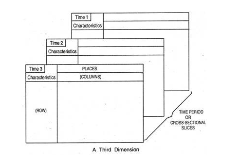
Brian J.L Berry has endeavoured to explain regional synthesis by using a geographic matrix, in which the traditional dichotomies are included as references. The geographic matrix highlights “the unity of the spatial viewpoint”.
It is assumed by Berry that complete ‘geographic data files’ are available so that data can be arranged in a rectangular array or matrix. The intersection of any row and column has been designated as cell.
Each cell is identified with a geographic fact. The geographic characteristic coincides with the row while the place under study coincides with the column.
Berry has explained regional synthesis with the help of a whole series of geographic matrices presented in their correct temporal sequence.
Idiographic approach
A method which stresses individuality and uniqueness of the phenomena as opposed to their similarities. Traditional regional geography has been represented as idiographic because of its concern for how areas and regions differed from each other.
Nomothetic approach
A law seeking approach concerned with the establishment and verification of generalisations about phenomena. In human geography it has been basis of the generally accepted paradigm since the quantitative revolution.
Q.2) Critically examine the changing perspective of the concept of areal differentiation. (20 marks)
Areal differentiation is the process by which geographers construct regions to describe and interpret differences in different areas of the earth’s surface.
Areal differentiation has its historical roots in the works of Hecateaus Miletus of 6th BC to whom geography is the study of regions.
Strabo in his works asserted that ‘geographer is the one who attempts to describe the parts of the earth’. Both Miletus and Strabo are concerned with study of different regions of the earth.
The term Areal Differentiation was coined and used by Hartshorne in is classical work The Nature of Geography in 1939. He considered the geography from the idiographic approach. He attempted t present the geography as a science concerned with functional integration of phenomena rather than with the processes of particulars kinds of phenomenon.
The perspectives developed during and after 1980s were different from earlier debates.
The first perspective came from, the humanistic geographers gave central and active role to the human awareness and human agency, human consciousness and human creativity. And employed areal differentiation to analyse the spatial pattern of the human activity. This approach focuses on human objective experience of a place.
The second from, the revival and analysis of the uneven development and changing spatial division of labour. Some geographers even applied Marxist approach to explain spatial variation in economic activity and well-being. This approach – division of space in socio-spatial processes.
The third from the attempts in geography to create contextual theory. This approach- sense of place arising out of the conditions created by socio-spatial processes.
Q.3) “Regional synthesis is the crux of geographical studies.” Elaborate (15 marks)
Hartshorne asserted that geography can benefit from both regional approach and systemic approach. Thus, he advocated the development of regional synthesis approach. Where regional studies should be based upon systematic studies.
Brian J.L Berry has endeavoured to explain regional synthesis by using a geographic matrix, in which the traditional dichotomies (human geography and physical geography) are included as references. The geographic matrix highlights “the unity of the spatial viewpoint”.
It is assumed by Berry that complete ‘geographic data files’ are available so that data can be arranged in a rectangular array or matrix. The intersection of any row and column has been designated as cell.
Each cell is identified with a geographic fact. The geographic characteristic coincides with the row while the place under study coincides with the column.
Berry has explained regional synthesis with the help of a whole series of geographic matrices presented in their correct temporal sequence.
Row-wise groups of variables coincide with the systematic or topical branches of geography and regions are represented by groups of columns. The cell represents the synthesis of the both systematic and regional geography.
The geographical matrix study enables us to study the spatial co-variations or spatial associations. The comparison of two columns in the matrix helps us to study the areal differentiation in its holistic sense.
The time dimension of the regional synthesis helps to analyse the spatial variations of geographical features over periods. Example – World fertility rate from 1971 to 2011. And changing spatial associations.
Q.4) Discuss the relevance of ‘Stop and Go Determinism’ in the present-day context. (15 marks)
Determinists generally consider humans as a passive agent on whom physical factors are working continuously and thus determine their approach and decision-making process. In short, the determinists believe that most human activities can be explained as a response to the natural environment.
Possibilism, on the other hand, argues that the relationship between man and nature is not so as human beings have the capacity to choose between a range of possible responses to physical conditions.
In the present-day context due to the influence of the possibilism there is over anthropocentrism and neglects the physical environment. The consequences of this are
– over exploitation of resources, environmental degradation, global warming, loss of biodiversity, rise in sea level, soil erosion etc.
In order to achieve the sustainable development ‘stop and go determinism’ is the best approach to the development of the region/nation and world as a whole.
According to this concept
– environment determines the best economic program for a nation/region.
– it is the geographer’s duty to interpret the program.
– man is able to accelerate, slow or stop the progress of a nation’s development. If he wise he should not depart from the direction set by the environment and he can change the pace of development. But the present-day development is largely deviated from the direction set by nature.
Example – commercial agriculture and green revolution met the short-term needs like food security. But meanwhile issues like soil erosion, soil degradation, water logging, change in cropping pattern, loss of genetic diversity of crops etc.
Thus, in short term people might attempt whatever they wished with regard to their environment, but in the long run nature’s plan would ensure that the environment won the battle and forced a compromise out of its human occupants.
Q.5) Discuss critically the manner in which quantitative revolution provided the methodological foundation for models and modelling in geography. (15 marks)
During the 1950s and 1960s, a revolutionary perspective developed as “Quantitative Revolution (QR)” in the discipline of geography. It replaced the ‘idiographic’ approach based on areal differentiation by ‘nomothetic’ one, which had its roots in the search for models of spatial structure and phenomenon.
It gave geography a scientific vision through the application of methodology rooted in statistical methods. Some of the elements of positivism, which had previously been not accepted at some point in time, were now accepted open-handedly. In the words of Burton (1963) this school had set out to discover universal laws, to build models and to establish methods and theoretical bases on which geographical realities could be erected.
How QR provided a foundation for model building
- All the techniques are firmly based on empirical observations and are readily verifiable.
- They help in reducing a multitude of observations to a manageable number of factors.
- They allow the formulation of structured ideas and theories which can be tested under the assumed conditions.
- They help in deriving suitable models to understand the interaction of the evolved factors and their process within the models and with reference to observed facts.
- They help in identifying tendencies and desired trends, laws and theoretical concepts.
The earliest use of quantitative techniques started in climatic studies e.g. Koeppen’s climatic classification, RR. Crowe’s The Analysis of Rainfall Probability, M.G. Kendall’s The Geographical Distribution and Crop Productivity in England, H.A. Matthew’s A New View of Some Familiar Indian Rainfall. Christaller made a major contribution to location theory, by applying quantitative techniques enormously in his study Central Places in southern Germany.
But, the models that were developed using quantification methodology were not an ideal representation of the real-world parameters and suffered from certain issues as mentioned below.
Challenges to the models built during QR
The theories and models developed on the basis of empirical data, do not take into account the normative questions like beliefs, emotions, attitudes, desires, hopes and fears and, therefore, cannot be taken as the tools explaining exact geographical realities.
The over-enthusiastic preachers have sacrificed many good qualitative statements which were quite useful.
They also demand sophisticated data which are rarely attainable outside the developed countries.
It has been found that generalisation done with the help of these techniques is bringing exaggerated results.
The factorial designs were dependent on the use of the costly computer time and considerable financial assistance which are rarely available to the individual researcher of areal variation.
Though the theory and model building traditions were normal in physical geography, the practise spread to the domain of human geography during the quantitative revolution. These models even now act as baseline ideal conditions for planners and designers but other than that they hardly have any use to study real-world geographical dynamism. Excessive emphasis on positivism, dehumanisation etc, eventually resulted in the ‘Critical Backlash’ phase in geographical studies where ‘man’ and human normative questions were brought back to the focus of geography.